13

Image allegedly from US Uncut

The above image claims that every major pipeline in the US cuts through Native American lands while avoiding white suburbs.

The text of the image states:

"It's interesting that every single big pipeline cuts right through the heart of Native American lands while completely bypassing white suburbs and golf courses. It's almost like they're doing it on purpose"

Is there any evidence to this claim?

7
  • 5
    If somebody is interested in checking this, here is a map of the pipelines and here one of the native american reserves.
    – Bakuriu
    Commented Sep 13, 2016 at 17:44
  • 4
    But then, you fall back on the semantics of a "big" pipeline. Irrespectively, it doesn't look like, from that map, that they're avoiding the suburbs of Dallas, Houston, St. Louis, Philadelphia, LA or Chicago. Commented Sep 13, 2016 at 17:52
  • 4
    It is also conceivable that Davey Williams defines native american lands more broadly than the US federal government does; that would make the claim impossible to address, as one might as well argue that all land in North America is/was native.
    – gerrit
    Commented Sep 13, 2016 at 18:12
  • 2
    it's probably notable that golf courses tend to be less than 150 acres while reservations are up to 17341609 acres.
    – Murphy
    Commented Sep 14, 2016 at 15:22
  • 1
    Something to keep in mind here: When you have to dig up the land to put something in you're going to want to go for areas with as little on them as possible. I would be very surprised at a pipeline going through a city unless it was meant to deliver to that city--and even then it very well might be a spur line to minimize the amount of city to be dug up. Commented Sep 17, 2016 at 0:23

2 Answers 2

14

No, not every single, 'big' pipeline passes through Native American lands. There are a lot of pipelines and they are arranged in a huge network, some terminating at both ends having never passed through Native American lands.

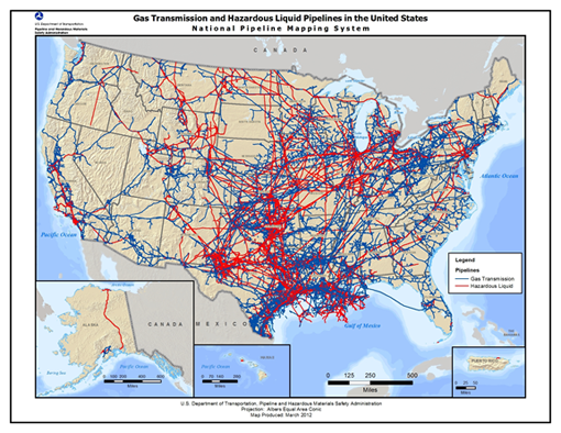
First, the claim is a bit weaselly. What is a 'big' pipeline? They don't define it. The US Department of Transportation (DOT) tracks all interstate pipelines and gathering lines. They don't manage intrastate lines, so I cannot speak on that. But since this claim is probably in reference the Keystone XL, we'll assume interstate pipelines. There are many factors that go into which pipelines the DOT tracks but generally it is 6" and up in size for low pressure systems.

As a local government official, I do have access to the USDOT GIS data of all 'major' hazard liquid and gas pipelines. Unfortunately, that GIS data is tied specifically to my person and there are explicit rules about how I use that data (for security reasons). I am a bit fuzzy on their position on sharing images, so would I feel uncomfortable sharing a US map of the pipelines. One way to describe what it looks like is a network of pipelines, not just a few spread around the US. A map of state highways and interstates is about the density of pipelines throughout most of the US.

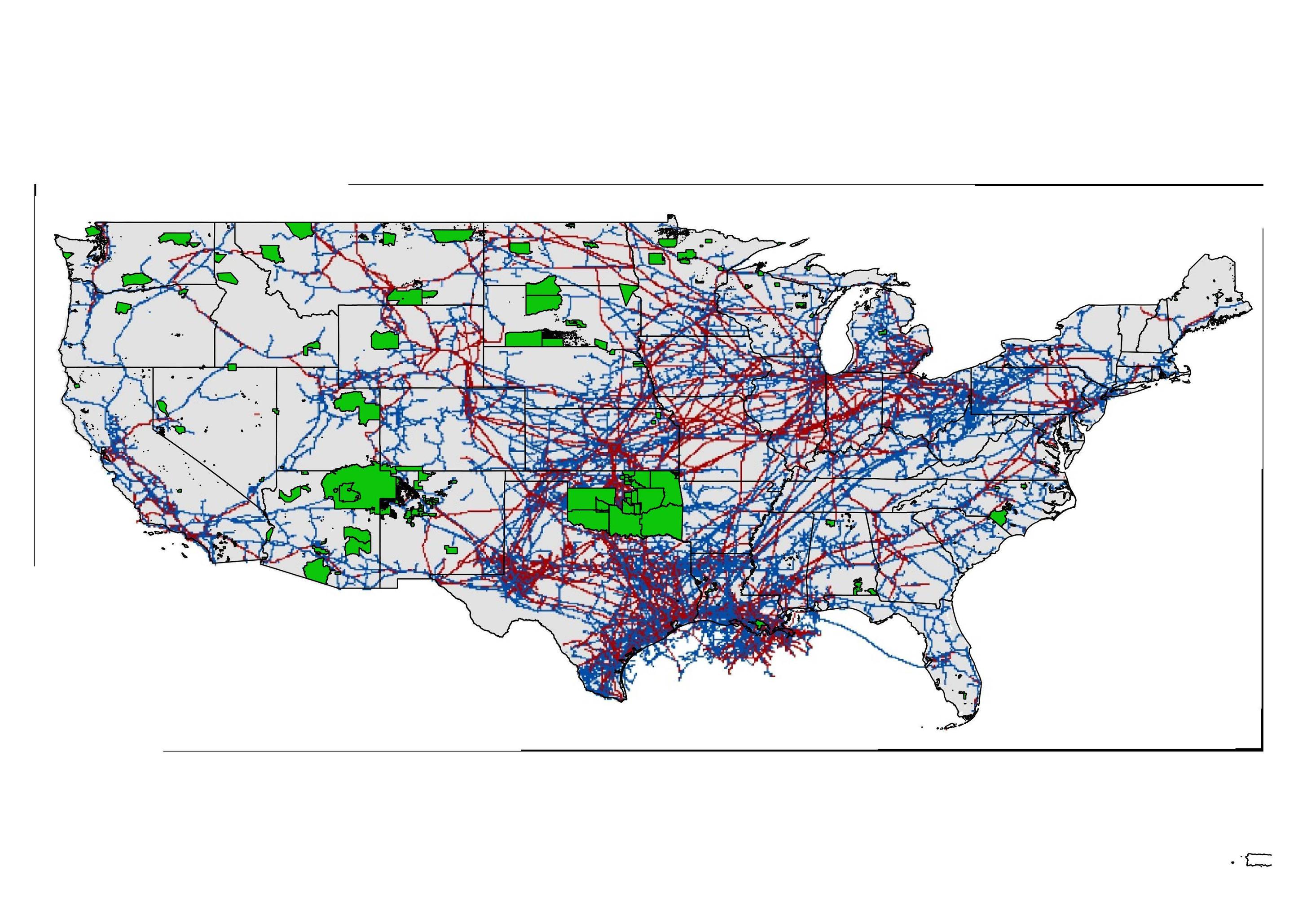
As you can see from the image, there are a lot of 'big' pipelines that do not even pass through Native American Lands. Hard to see in this photo, but some lines make an effort to avoid passing through the Crow Reservation in southern Montana; no idea if this was due to protests, risk assessments, or avoid litigation.

Pipelines in the US with Native American Federal Lands superimposed. USPipelines
You can view maps of pipelines by-county here: https://www.npms.phmsa.dot.gov/PublicViewer/


In finding the definition of what lines the DOT tracks, the map on the front cover of this PDF is very close to the data I have. https://www.npms.phmsa.dot.gov/Documents/Operator_Standards.pdf
enter image description here

1
  • 1
    Good answer, though I'd note that, given the timing, it seems more likely the meme was addressing the Dakota Access pipeline than Keystone XL. Amusingly, DAPL itself doesn't actually pass through any native American reservations. The complaints are coming from a reservation whose closest border is 1/2 mile away from DAPL's route.
    – reirab
    Commented Feb 8, 2017 at 21:43
16

I can't fully answer the title question but I will address part of the quote that it's based on in your post.

I'm not going to attack the whole statement but I will include some counter examples to part of it.

completely bypassing white suburbs and golf courses.

From a quick search here's an example of a pipeline through a golf course.

These sites, termed Early Construction Areas (ECAs), include several river and wetland complex crossings, and two miles of pipeline through the Lake Arrowhead Golf Course and an associated residential area

it's probably notable that golf courses tend to be less than 150 acres while reservations are up to 17341609 acres. So it can make golf courses easier to bypass.

Golf courses are also apparently not great for underground pipelines since the companies are often legally obliged to return the site to it's previous state if they need to dig for maintenance (expensive on a golf course) and golf courses sometimes do landscaping which can make damage to the pipeline more likely.

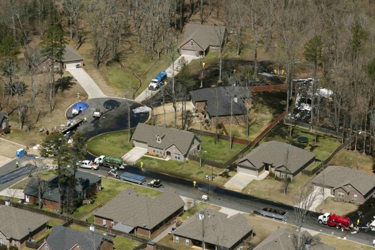
here's an example of a pipeline which burst in a suburb in Little Rock, Mayflower :

enter image description here demographics of mayflower are 95.16% White

In terms of the other half of the quote, it's extremely hard to find a suitably clear example since even if a pipeline doesn't go anywhere near any official reservations it may still pass through land that native groups claim to be theirs or through land which isn't a reservation but does legally belong to citizens of native descent.

Some pipelines have little in the way of online information available about them without articles obviously talking about native protests related to them but that is merely absence of evidence.

4
  • This disproves the claim "big pipelines completely bypass white suburbs and golf courses" but not yet the claim "every big pipeline cuts through the heart of native american lands".
    – Philipp
    Commented Sep 15, 2016 at 14:21
  • 1
    @Philipp I freely admit that. I suspect it would be a slow labourious task to check the route of each pipeline to see if it intersects any reservations.it's also debatable whether official reservations constitute all "native american lands" as far as the speaker is concerned,
    – Murphy
    Commented Sep 15, 2016 at 15:38
  • I can find one "major" pipeline that assuredly does not run through Native land. Trans-Alaska Pipeline System runs north-south through the state. The only reservation in Alaska is Annette Island in southeastern Alaska, well outside of the pipeline's path. However, TAPS was built after the federal government passed an act buying out reservations on the path, but still it technically does not run through any
    – Jimmy M.
    Commented Sep 15, 2016 at 16:11
  • 4
    @JimmyM. this is where the difference between official reservations and "native lands" comes in. A quick read of the wiki en.wikipedia.org/wiki/Trans-Alaska_Pipeline_System includes a large section on Native objections and land claims. Tlingit natives sued and got a settlement so they must have had a reasonably compelling case lasting decades.
    – Murphy
    Commented Sep 15, 2016 at 16:19

You must log in to answer this question.

Not the answer you're looking for? Browse other questions tagged .